Sponsoring companies
![]()
![]()

![]()


![]()
Mineral prospectivity modelling
A geographical information system (GIS) is designed to manage and utilize spatial data. GIS can be used as a tool for making maps or analyzing spatial data. In this project a variety of digital geoscientific data, i.e. geological, geochemical and geophysical, are used as spatially referenced layers of evidence in mineral prospectivity mapping (also known as exploration targeting or mineral potential assessment), that is, ranking areas according to their exploration importance.
There are several mathematical and statistical techniques available for recognizing patterns in spatial data, thereby making effective use of the exploration data that is collected continuously by exploration companies on annual basis. This quantitative analysis of spatially referenced information is also called spatial data analysis or spatial modeling, in which the spatial distribution of the observations is taken into account in data analysis and interpretation of the results. The simplest and/or most common functions or operations for spatial data analysis, which are available in most GIS software, include extractions, buffering, overlays, proximity analysis, shortest path calculations, map algebra and raster analysis.
However, there is a variety of advanced machine leaming methods available for spatial modeling applied to mineral prospectivity mapping, and the selection of a specific technique is often made depending on the data that are available. Bonham-Carter (1994) divides these spatial modeling methods into two main groups based on the approach: data and knowledge driven. For 'brown-fields exploration' in mature mineral exploration terrains, where abundant data are available and many mineral deposits are already known, an empirical (or data driven) approach is very often applicable. In techniques for empirical spatial modeling, known mineral deposits are used for 'training' the model, for example, (a) to define appropriate thresholds for geophysical and/or geochemical data or (b) to answer the question 'how close is close?', if proximity to certain mapped features is considered favorability criterion for the mineralization type concerned. These data-driven techniques include e.g. weights of evidence, logistic regression and artificial neural networks. The potential of these methods is demonstrated by numerous scientific papers but they are currently underutilized in operational mineral exploration.
In ‘green fields’ cases where no known occurrences of the deposit type being modeled or the number of the deposits is too low to make valid statistical calculations, a conceptual (or knowledge-driven) approach can be used. In techniques for conceptual spatial modeling, expert opinions are used to define the thresholds. The knowledge-driven techniques include applications of fuzzy logic, evidential belief function, the Dempster-Shafer model and the decision tree approach.
Even though the spatial modeling techniques can be roughly divided into these two groups, the individual approaches are not necessarily purely empirical or conceptual. For example, when conducting empirical weights-of-evidence modeling, objective expert decisions are made in selecting the training sites or evidence data to be used. Furthermore, fuzzy input layers can be used as evidence in an empirical modeling technique, and expert input is brought into the modeling in that way. In cases where minimal expert input takes place, purely empirical spatial modeling techniques would actually fit into the category of spatial data mining, which is a field where vast spatial databases are analyzed to find unexpected correlations or patterns within the data. Self-organizing maps (SOMs) are prime examples of data mining techniques.
Mineral exploration is done in several scales from regional to target scale. The MPM project aims at creating workflows and tools to optimize the target scale modeling by adding new information into the models during the project evolution, which can take several years. This will be demonstrated by using a historic case study. In a typical mineral exploration project the amount of data is increasing in the course of the project but the information gained might not increase parallel. The MPM project aims to solve this issue by providing updated tools for data exploration.

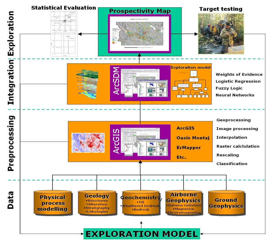
Typical workflow of a mineral prospectivity modelling project (Nykänen 2008).
Bonham-Carter, G.F. 1994. Geographic Information Systems for Geoscientists – Modelling with GIS. Computer Methods in the Geosciences 13. Pergamon, Oxford, 398 p.
Nykänen, Vesa 2008. Spatial data analysis as a tool for mineral prospectivity mapping. Espoo: Geological Survey of Finland. 27, [92] p.


