


WP2: Data collection and monitoring
Need:
Online monitoring and data transfer systems are needed in the mine site to enable data flows from the site to on-line water balance calculations. The fouling of sensors is a significant problem in monitoring of mining sites with polluted waters. The reliability of measurements depends on the state of the sensors and correct positioning. In addition, the topography in the mining area needs to be precisely known for surface water movements.
The data for the geometry of the groundwater flow model and part of the hydrogeological properties has to be collected manually. Online monitoring can later be applied for specific parameters.
The data collection for the geometry of the groundwater flow model or the hydrogeological model comprises extensive geological and geophysical studies, including section logging, drillings in Quaternary sediments and bedrock, geomorphological interpretation from maps and digital elevation models and measurements with several geophysical methods depending on the geological properties of the area and to reduce the uncertainty of the interpretation.
The data collection for the hydrogeological parameters and parameterization of the groundwater flow model includes e.g. slug tests, pumping tests, measurements of groundwater and surface water heads and geomorphological interpretation.
Hydrological and water quality parameters can be measured using online monitoring. Manual discharge measurements and water sampling is needed alongside with the online monitoring. Discharge measurements are needed to evaluate the reliability of online monitoring and to measure discharges in places where online monitoring stations are not built. The online monitoring of water quality is problematic because of the need for the sensor calibration and maintenance, but also because of the lack of specific sensors for different substances. Therefore, water sampling and geochemical analyses are needed to find out the crucial parameters that can tell about the change in water quality (e.g. pH, Eh, EC).
Problem:
Data collection of the terrain and groundwater can be challenging an in offline mode time consuming. There are also gaps in the present automatic monitoring of hydro-meteorological processes, like evaporation and soil moisture. Several online systems are available for water quantity monitoring. However, because the monitoring has to be performed under challenging field conditions, sensors’ installation, power supply and maintenance related problems need to be faced. Data logging and transfer from these monitoring locations to the application architecture need to be solved.
Solution:
We will use on-line equipment to gather hydro-meteorological forecast and measurement data of water quality and volumes in the area and volume data and several other parameters needed for successful water balance modelling. We will improve the use of laser scanning technique to map and identify watersheds and flow directions in the mine area. We will use online systems for monitoring water quality. Water quality variables such as temperature, pH, mV, conductivity and turbidity, are measured to separate ground water from surface water discharges as well as clean water from dirty water discharges. Also airborne thermal measurements and studies of the isotopic composition of the water are used depending on the study area. A special attention will be paid to data quality assurance i.e. to secure that sensors remain operable. We shall look for new practices in service. Feasible monitoring solutions and services offered by a competent supplier will be utilized.
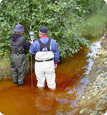
Virtaamamittaus.
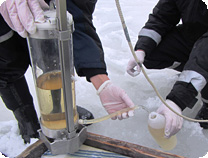
Vesinäytteenotto. Photo: Kaisa Turunen, GTK

